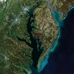
The Chesapeake Bay score decreased in 2018, but maintained a C grade, according to the 2018 Chesapeake Bay Report Card issued by the University of Maryland Center for Environmental Science (UMCES).
The decrease was due to extremely high precipitation last year, according to UMCES. The report indicates that, overall, Chesapeake Bay health is improving over time.
Almost all indicators of Bay health, such as water clarity, underwater grasses, and dissolved oxygen, as well as almost all regions, declined in 2018.
In particular, chlorophyll a and total nitrogen scores had strong declines due to very high rainfall causing nutrient runoff that then fed algal blooms.
However, the overall Bay-wide trend is improving. Since 2014, all regions have been improving or remaining steady.
Of the many factors that affect Chesapeake Bay health, the extreme precipitation seen in 2018 appears to have had the biggest impact. The Baltimore area received 72 inches of rain in 2018, which is 170% above the normal of 42 inches.
As a result, the reporting region closest to Baltimore; the Patapsco and Back Rivers saw a decline in health, decreasing to an F grade in 2018.
The strongest regional declines were in the Elizabeth River and the Choptank River. The two regions that remained steady were the Lower Bay and the York River.
Fish populations received a B grade, showing a steep decline from the previous year’s score of A.
Striped bass numbers sharply declined in 2018, while blue crab and bay anchovy scores declined somewhat (although blue crab are showing a revival in early 2019). These drops in scores are a cause for concern as smaller populations could lead to further declines in the future.
Actions that individuals can take to contribute to a cleaner Bay include reducing fertilizer use from all sources, carpooling and using public transportation, and connecting with people across the entire Bay Watershed to work together.
This is the 13th year that the University of Maryland Center for Environmental Science’s Integration and Application Network has produced the report card. It is the longest-running and most comprehensive assessment of Chesapeake Bay and its waterways.
For more information about the 2018 Chesapeake Bay Report Card including region-specific data, visit chesapeakebay.ecoreportcard.org.
source: University of Maryland Center for Environmental Science
Leave a Reply
You must be logged in to post a comment.